About
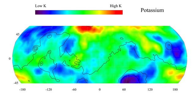
This gamma ray spectrometer map of the mid-latitude region of Mars is based on gamma-rays from the element potassium. Potassium, having the chemical symbol K, is a naturally radioactive element and is a minor constituent of rocks on the surface of both Mars and Earth. The region of highest potassium content, shown in red, is concentrated in the northern part of Acidalia Planitia (centered near 55 degrees N, -30 degrees). Several areas of low potassium content, shown in blue, are distributed across the mid-latitudes, with two significant low concentrations, one associated with the Hellas Basin (centered near 35 degrees S, 70 degrees) and the other lying southeast of Elysium Mons (centered nea — NASA JPL · 2003. ABD devlet eseri: kamu mali, ticari islerde de serbestce kullanilabilir.
Source and licence
This work is public domain or openly licensed. The licence terms are published by the source.
How do I open it?
Use the Shopy 101 app to download it or read it in place. Anything you add to your library stays the same on every device.